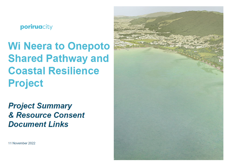
We’re working to develop a shared pathway between Wi Neera Drive and Onepoto and provide coastal resilience along the harbourside edge of Titahi Bay Road and Wi Neera Drive. We've come a long way, but there’s still a lot of work to do – find out more below. You can contact the project team at [email protected]
On this page you’ll find:
Latest project update
Update on the shared path and coastal works project
After more than two years of hard work, the final resource consent for this project has been granted. This is a major project milestone.
Final construction plans and specifications are well advanced and expected to be completed in July 2024. At that stage it had been intended to approach the market for construction, however this is now very uncertain due to a change in Government funding priorities, and significant cost escalations.
We expect to know more before September this year and will continue to keep you updated on this.
In the meantime, if you would like to view the shared pathway resource consent documentation, follow the link here.
Going places with the shared path and coastal works project
It’s full steam ahead for the Wi Neera to Onepoto Shared Pathway and Coastal Resilience Works project. As you know, we were thrilled to be granted resource consent for the coastal resilience part (stage A) of the project back in February 2023.
With the support from Ngāti Toa Rangatira, the resource consents required for the shared pathway component (stage B) were lodged with Greater Wellington Regional Council and Porirua City Council on 7 December 2023. We should hear back on whether the application has been successful early next year.
Engineers are onboard and well underway with carrying out detailed design. Tonkin & Taylor (along with support from Isthmus for landscape design, and Salt Ecology for ecological input) were awarded the contract. Final design drawings for the pathway, and coastal edge trees, shrubs and saltmarsh, will be complete by March 2024. We then hope to be going out to the market for the construction contract in quarter two of next year.
A further land use resource consent was granted in June 2023, confirming a site for the construction operations (including a site office and construction machinery / equipment storage during the construction period). This site is located close by, at Takapūwāhia Reserve. The construction phase of the project is aimed to get underway in July 2024.
We are excited to be making real progress and look forward to sharing with you the final design drawings once they have been finalised. We will continue to keep you updated as the project progresses.
We will make the shared pathway resource consent documentation available here in the new year (January 2024).
Wi Neera to Onepoto Shared Pathway and Coastal Resilience Project - A major milestone achieved
Download the report here
Resource consent granted for Wi Neera to Onepoto shared pathway and coastal resilience project
It has been a long time coming, and has involved a huge amount of effort and support, but we are very pleased to announce that the coastal resilience part (Stage A) of the Wi Neera to Onepoto Shared Pathway and Resilience Project has been granted resource consent. The project team received the consents from Porirua City Council on 22 December 2022 and Greater Wellington Regional Council on 9 February 2023.
This means that we can now proceed with the detailed design phase for Stage A of the project. The planning for getting engineers onboard to help do the detailed work has already started.
The project, which will be a fantastic asset for our community and of enormous benefit to harbour health; has been a large undertaking. Getting this far has taken a huge amount of effort and support. We will keep you updated as the project progresses.
To make it easier to open all the documents linked within the report above, right-click on your mouse and select 'open link in new tab'.
We are really pleased to announce that on Wednesday 2 November, Council lodged its resource consent application for the coastal resilience part (Stage A) of this project.
The consent application and supporting information is now available at the link above. The consent application itself has 31 documents attached ranging from the actual application forms to detailed assessment of effects documents such as wave height modelling, a cultural impact assessment, stormwater assessments and community engagement!
29 September, 2022
We had hoped to have the resource consent application for Stage A: Coastal Resilience Works updated and lodged by 30 September 2022.
Consent authorities have since asked for one further piece of work - identifying a site for construction operations. The site is an area that will contain the site office and construction machinery equipment during the construction period. We have identified a site and are now preparing a plan for how the site will be managed during the construction period. Once we have the plan developed, permission to use the site will then be required under the Reserves Act and from neighbouring property owners.
The resource consent application will be lodged in October, once this matter is sorted.
25 August, 2022
Kia ora,
Porirua City Council has been working on a resource consent application for the Wi Neera to Onepoto Shared Pathway and Coastal Resilience Project. The consent-level plans, assessments and reports have now been finalised.
Where is the project at?
A land ownership matter has been identified, which needs to be resolved before the shared pathway can be built.
A Cultural Impact Assessment (CIA) was recently carried out by the Te Rūnanga o Toa Rangatira (Ngāti Toa), as part of the necessary resource consent documentation. New information came to light which shows that land ownership for a parcel of land covering a small part of Titahi Bay Road (Pt Tutae Paraikete 1) does need to be resolved by a formal application to the Māori Land Court.
While Council and our project partner, Ngāti Toa, were historically aware of the matter, previous discussions at the time indicated that it wasn’t an issue that would impact the project.
We want to press ahead with the vital harbour restoration part of the project, while the land ownership matter (which impacts the shared pathway) progresses through the Court.
To do this, we are splitting the project into two stages – applying first for resource consent for the coastal resilience/erosion work, as this aspect of the project remains unaffected by the land ownership matter, then consent for the shared pathway will follow once the land ownership is resolved.
This may create some delays, but the alternative was to pause the entire project until the land matter was resolved, which would create longer delays and prevent the much-needed erosion control work on the harbour margin from beginning.
What does this mean?
We are now delivering the project in two stages:
- Stage A: Coastal Resilience Works
- Stage B: Shared Pathway
Stage A: Coastal Resilience Works
Resource consent will be submitted within the next month to both Porirua City Council and Greater Wellington Regional Council. This will focus on:
- Repairing the historic and current road edge erosion
- Improving future resilience against coastal erosion and effects of sea level rise associated with climate change
- Restoring landscape quality of harbour edge
- Improving ecological values (inner harbour)
Stage B: Shared Pathway
Once the land ownership is resolved we can proceed with submitting the resource consent for the shared pathway. This stage includes any physical works for the proposed shared pathway and information on the history of the area.
How long will it take?
Even though we are submitting resource consent for Stage A (Coastal Resilience Works) at this point in time, the design takes into account the construction of the shared pathway and associated works at a future date.
Assuming resource consent is successfully granted, we are estimating summer of 2024/2025 for construction of the coastal resilience works to begin.
For Stage B, due to the legal nature of this matter, it may take a while to progress and it is difficult for us to put an estimated timeframe on this. We will continue to keep you updated.
How much will it cost?
The initial estimate project cost of $11.8m was based on 2020 construction rates. There has been an approximate 15% increase in construction rates over since then.
As we progress through the concept design stage of the project, we also have a better understanding of what the required detailed tasks, investigation and assessments are.
As at May 2022, the estimated project costs are $16.4m. Now that we are progressing with staging the project, this estimate could change. During the detailed design phase of this project, costs will be better defined and the contingency allowance will likely be reduced.
Where will the funding come from?
Although Council have agreed to underwrite the project at $16.4m, it is still anticipated that this will be subsidised by funding opportunities such as Waka Kotahi and Lottery Funding Grants.
What does the final concept design look like?
As soon as resource consent is lodged, all resource consent documentation for both Stage A and Stage B will be made available on our website. This will include the visual concepts, consent-level plans, assessments, reports and application.
6 May, 2021
Kia ora,
Good progress has been made on the resource consent application.
We anticipate lodging with Greater Wellington Regional Council at the end of June. We realise this is slightly later than anticipated, but we have been working hard to get this right.
We now have all of the detailed drawings prepared and engineering assessments undertaken. Our consultants have been working hard to provide all of the necessary inputs required in order to draft the resource consent application.
The final tasks that we need to complete include:
- Finalising the consent-level designs, Cultural Impact Assessment and the coastal, ecological, landscape and environmental impact assessment reporting;
- Checking-in with the project stakeholders, and see if there is any further feedback;
- Providing the complete final draft of the resource consent application package to Te Rūnanga o Toa Rangatira, GWRC, Porirua City Council consenting, Wellington Water, Department of Conservation and Porirua Harbour & Catchments Community Trust.
How are we doing on project funding?
As part of preparing an application for funding, we discussed the project with the Lottery Significant Project Fund. Their advice has been that they require a resource consent to be in place before lodging an application. We will continue to look at other appropriate Lottery funding grants as well as additional funding options for this project.
We are continuing to work with Waka Kotahi to ensure all the required information is ready in advance of their upcoming funding rounds to enhance our ability to ‘unlock’ Waka Kotahi funding for the detailed design and construction phases.
What’s next?
Once the final resource consent application has been lodged, all the documentation will be made available for the public to view from our website
Background
Council has agreed to progress with a preferred option for the Wi Neera to Onepoto Shared Pathway and Coastal Resilience Project.
Delivery of the project is subject to resource consents and to securing external funding, so there is still a lot of work to do.
The preliminary concept design for the preferred option includes:
- construction of a 1.4km shared cycling and pedestrian pathway along Titahi Bay Road between Wi Neera Drive and Onepoto, and
- erosion protection works to enhance coastal resilience along the coastal edge of Titahi Bay Road and Wi Neera Drive.
We believe this is the best solution to deliver on the project objectives; to improve cycling and pedestrian connection and address harbour edge erosion and coastal resilience. This preliminary concept design has been shaped by feedback from community and stakeholder engagement in recent years.
The preferred option we are progressing with has an estimated construction cost of $10.7m; $4m for the pathway, $6.1m for coastal resilience alongside Titahi Bay Road, and $0.6m for Wi Neera Beach improvements. (30% contingency is built in.)
The final cost won’t be known until we have obtained resource consent, completed detailed design and expert costing reviews, and we have a preferred tenderer.
Based on the current estimate, Council would need to contribute $3.6m to the project, which is being sought through the Long-Term Plan. Further funding is being sought from Waka Kotahi NZ Transport Agency and external funding sources.
If Waka Kotahi and external funding can’t be secured, the project will be closed, and the capital funding returned to the Transport renewal programme, and to City Partnerships to complete Wi Neera Beach (subject to resource consent).
Coastal erosion issues along Titahi Bay Road would be managed through the business as usual transport maintenance programme.
We look forward to your feedback and to seeing you at a drop-in information session.
Previous community & stakeholder updates
Kia Ora
We’re pleased to be able to update you on recent progress.
Consent-level Design and Resource Consents:
We’ve further refined some elements of our coastal resilience design for the harbour edge following feedback from Te Rūnanga o Toa Rangatira and Wellington Water.
The feedback was received as part of the work to develop the consent-level designs and documentation to support resource consent applications to Greater Wellington Regional Council (GWRC) and Porirua City Council (PCC). Some key refinements to the coastal design include:
- extensions to the areas of saltmarsh planting directly north of the Wi Neera corner and at the Onepoto end (resulting in less rock armouring alongside Titahi Bay Road)
- changes to the alignment of the rock sills (Chenier's) that define the outer edge of the saltmarsh planting (so the sills now meander and have a more natural appearance), and
- refinements to some of the stormwater outlet treatments along the harbour edge (identified in consultation with Wellington Water and balancing how stormwater can best be managed and future-proofed, alongside the need to protect the saltmarsh).
The updated consent-level designs for the shared pathway and Titahi Bay Road now include some small adjustments to the existing bus stop locations, as well as two new crossing points and three possible harbour-side pause points in the north and south sections and near Ti Pene Ave. We’ve also had an external road safety expert review these changes (as well as possible revisions to the existing speed limit alongside Titahi Bay Road) to ensure any identified risks to users are minimised.
Some elements identified within the consent-level designs, such as the pause points and the stormwater outlet requirements, will be further developed and costed during detailed design.
We’re hoping to wrap up these revisions within the next week, at which point we’ll share the plans and other supporting information with Te Rūnanga o Toa Rangatira, so they can complete their Cultural Impact Assessment. Our technical specialists will also be able to complete their coastal, ecological, landscape and environmental impact assessment reporting, which will inform the draft resource consent applications to GWRC and PCC. We’ll then be able to share these with GWRC and the Department of Conservation (and other key harbour stakeholders) for review and feedback prior to lodgement. Alongside this we’ll check-in with other project stakeholders (including Waka Kotahi NZ Transport Agency, Porirua Harbour Trust, harbour user groups and local emergency service providers) to progress our earlier discussions and seek feedback on the latest changes.
As soon as these consent-level designs are complete we will share them with you and make them available on the project webpage. This will include a concept illustration (currently underway) showing what the proposed Wi Neera Beach could look like.
Project Funding:
The ability to complete the project is no longer contingent upon Waka Kotahi and external funding, as Council has agreed to underwrite the project if external funding can’t be secured. That said, we’ll be actively seeking external funding over the next 12-18 months, to reduce the Council share. Preparations are underway for an expression of interest to the Lottery Significant Project Fund (which has a “soft close” between October and December this year) in advance of formal applications closing (for three Lottery funds) in March 2022. We’re also continuing to work with Waka Kotahi to ensure all the required information is ready in advance of upcoming funding rounds to enhance our ability to ‘unlock’ Waka Kotahi funding for the detailed design and construction phases.
We’ll continue to give you progress reports as we have information to share.
This update is to let you know how the Wi Neera to Onepoto Shared Pathway and Coastal Resilience Project is tracking and what the next steps are.
We are progressing well with developing the consent-level designs and documentation to support resource consent applications to Greater Wellington Regional Council and Porirua City Council.
The aim is to lodge these applications within the next couple of months, and we are doing all we can to achieve a non-notified consent process to save time and money.
The package of work being developed for the consent applications includes (among other things):
- A detailed statement of the proposal
- A construction methodology for the coastal resilience works and the pathway, which details how the work would be staged over two summer seasons
- Design statements and ecological plant species palettes (for all of the planted areas, including the saltmarsh wetland)
- Landscape, ecological, environmental effects and cultural impact reporting.
We’re grateful for the input of Ngāti Toa, our partner on this project. Their endorsement of the proposal is critical to achieving a non-notified resource consent process. Our revised time-frame for lodging the resource consent applications allows for further discussions, and to allow for refinement of the consent-level design prior to finalising the environmental and cultural impact assessments.
Closer consideration of the design for the coastal resilience works has also been informed by feedback from Ngāti Toa, stakeholders, the community and Wellington Water.
Some elements of the design being reviewed following feedback include:
- Realignment of the rock sills to naturalise their appearance where possible
- Opportunities to widen some areas of saltmarsh planting (and slightly reduce the rock revetment) alongside Titahi Bay Road
- Investigating whether future pause points can be incorporated into the consent-level design
- Confirming stormwater requirements and refining elements of the coastal design (including stormwater outlets) to incorporate data from Wellington Water’s recent catchment modelling.
The team is also preparing an Expression of Interest (EOI) to the Lottery Significant Project Fund, which closes in October. Feedback from this process will help us refine our formal application to the fund, which closes in March 2022. We’re also investigating other funds, including the Community Facilities and Environment and Heritage Funds (among others) which also close in March next year.
The Long-term Plan includes a capital budget of $10.7m for the shared pathway and coastal resilience project: $3.6m (PCC), $3.9m (Waka Kotahi - NZ Transport Agency) and $3.2m (external funding sources). This is in addition to the $720k budget for pre-implementation works through to obtaining resource consent. (While this includes a $40k allowance for a non-notified consent process, the cost of a notified process could be in the order of $250k.)
June 2021
The project is progressing well and we’re keen to update you on a few things.
Project Budget and Funding:
Porirua City Council has formally adopted its Long-term Plan (LTP) 2021-51 which sets the direction and budget for the next 30 years.
The LTP includes a newly-agreed capital budget of $10.7m for the shared pathway and coastal resilience project. This is broken down as: $3.6m (PCC), $3.9m (Waka Kotahi - NZ Transport Agency) and $3.2m (external funding sources). The ability to complete the project is also no longer contingent upon external funding - as Council has agreed to underwrite the project if Waka Kotahi and external funding can’t be secured.
Waka Kotahi is one of our project partners and has been closely involved in, and helped shape, the project to date. Waka Kotahi has previously agreed to part-fund the project through to obtaining resource consent and we’ll continue to work closely with our Waka Kotahi Investment Advisor in the coming months to further maximise the funding opportunities available towards the upcoming design and capital works stages of the project.
We also have a Funding Plan which includes requesting additional funding from other funding organisations. Applications will be lodged to the Lottery Community Facilities and Significant Project Funds (among others) when they open later in the year - beginning in September. Other potential funding sources with a focus on environmental, cultural and heritage outcomes are also being investigated.
Key themes raised in recent feedback on the preliminary concept design:
Some of the key themes from recent feedback on the preliminary concept design included:
- Strong support for amenity features, such as seating, lighting, pause points, etc
- The need to ensure current design parameters demonstrate compatible outcomes (i.e. a safe pathway that is suitable for use by a wide range of users)
- The need for the design to consider the safety of all users travelling along and across Titahi Bay Road - with attention to be paid to:
- Pedestrian refuges
- Safe crossing points (for cyclists and pedestrians to access the pathway), e.g. Te Pene Avenue
- Possible extension of the pathway to the zebra crossing (at the northern end)
- Measures to minimise conflict between cyclists, pedestrians and vehicles
- Mixed views on the proposal to narrow the vehicle lanes (some people noted potential impacts on vehicle access, emergency service response times, travel times, available parking space and safety)
- Mixed views on the proposal to remove harbour-side parking (some people were concerned about a potential increase in parking-related pressures at peak times and during events, and vehicle congestion)
- Mixed views on the proposal to reduce the speed limit to 50km/h along the full length of Titahi Bay Road (some people noted this could slow travel times and add to existing congestion within the 50 km/h sections)
- The need to ensure the pathway is pathway non-linear (i.e. not a straight line) where possible
- The need to ensure the design provides for future sea level rise
- The need to ‘future-proof’ the shared path (by increasing the pathway width) to enable it to cater for increased demand over time - and allow for future separation of pedestrians and personal electric vehicles
- The need to consider the needs of harbour users / water-sport groups (e.g. rowing and waka ama) and create some bays for motorists/spectators to stop and take photos, watch events, etc
- The funding shortfall and ability to source the additional funding required
- Treatment of the buffer zone between the southbound land and the shared pathway
- Traffic Management requirements during construction.
We’re continuing to work through the points raised (including the many questions asked). Your feedback, plus input from our technical specialists, is helping to shape the consent-level design (currently underway) and also guiding our discussions with project stakeholders. Some items we’re exploring in more detail with project stakeholders include:
- Stormwater design considerations
- Further investigation of potential impacts of a change in speed limit
- Access (and requirements for) for emergency services
- Possible future-proofing of the design (to accommodate future growth and/or incorporate amenity features later on as funding permits)
- Needs of harbour users/water-sport groups (e.g. rowing and waka ama).
Consent-level design and resource consent applications:
Work that’s currently underway includes preparation/development of:
- Consent-level design for the shared pathway and coastal resilience works (also incorporating feedback from our technical specialists)
- Concept Safety Audit assessing options for, and potential impacts of, a change in the current speed limits along Titahi Bay Road
- Ecological plant species palettes (for all of the planted areas, including the saltmarsh wetland)
- Cultural impact assessment
- Environmental effects reporting and compilation of background information for the consent process
- Resource consent applications (to Greater Wellington Regional Council and Porirua City Council)
- Review and refinement of project schedules (materials, quantities and volumes, and costings).
We’re also continuing our engagement with Ngāti Toa and other stakeholders and this will include a project update to Ngāti Toa’s Kaumatua Committee in early July.
The target timeframe for lodgement of the resource consent applications is the first quarter of 2021/22 - and the earliest possible commencement of construction (assuming non-notified consents and funding availability) is summer 2022.
In our next update we hope to further detail how the project has responded to feedback received and provide responses to the many questions raised. We’ll also make this information available on the project webpage https://poriruacity.govt.nz/your-council/city-projects/wi-neera-onepoto-shared-pathway-coastal-resilience-project/
Kia ora,
Thanks to all those who attended our recent ‘dop-in’ project information sessions and who gave feedback on the preliminary concept design for the shared pathway and coastal resilience works. It was good to meet some of you, talk through your areas of interest, and answer your questions.
Your feedback is appreciated and the team is currently working through all of the points raised. We’ll also be sharing this with our wider team in the coming weeks, as they get underway with the consent-level design and assessment of effects reporting to support the necessary resource consent applications.
We hope to get back to you again in a few weeks, to explain how the project is responding to the feedback received, and to share our responses to the questions raised in written comments. We’ll also be continuing our engagement with Ngāti Toa and other stakeholders and this will include a project update to Ngāti Toa’s Kaumatua Committee in the coming weeks.
You can find more about the project, the preferred option, and next steps on our project webpage.
Ngā mihi
The Project Team
Kia ora,
This is a friendly reminder that feedback closes tomorrow (Friday 19 March) on the preliminary concept design for the preferred option for the Wi Neera to Onepoto Shared Pathway and Coastal Resilience Project.
You can find more about the project, the preferred option and the next steps on our project webpage.
Send your feedback to us by email to [email protected] . (Our thanks to those who’ve already provided feedback.)
If you’d like to give feedback, some things you might like to think about are:
- Separation between pathway users and vehicles on Titahi Bay Road
- Narrowing of the Titahi Bay Road vehicle lanes
- Lighting
- Seating
- Stopping points along the pathway
- Other elements of the design.
While the feedback on the preliminary design finishes tomorrow, we are always happy to answer questions and to take further comments as we move on with the project.
Ngā mihi
The project team
New drop-in information session and extended time for feedback
We’re pleased to confirm that we’ve re-scheduled the second ‘drop-in’ project information session to Tuesday 9 March.
This is great opportunity to hear more about the Wi Neera to Onepoto Shared Pathway and Coastal Resilience Project. We’ll have members of the project team available to talk to you about the project, answer your questions, and hear your feedback.
When: Tuesday 9 March from 4pm to 7pm
Where: Whitireia New Zealand (Porirua campus) – Room WK160 (which is located in the red-circled area below).
Feedback
Our thanks to all those who have given their feedback so far.
Because we value your feedback we’ve also extended the timeframe for public feedback on the preliminary concept design to Friday 19 March.
If you’d like to give feedback, some things you might like to think about are:
- Separation between pathway users and vehicles on Titahi Bay Road
- Narrowing of the Titahi Bay Road vehicle lanes
- Lighting
- Seating
- Stopping points along the pathway
- Other elements of the design.
You can find more about the project, the preferred option, next steps and give feedback on our project webpage.
Invitation to drop-in project information sessions & feedback reminder
Following on from our recent update email, we’d like to invite you to a drop-in information session on Saturday February 13 and Tuesday February 16 to hear more about the Wi Neera to Onepoto Shared Pathway and Coastal Resilience Project.
We’ll have Council staff and expert consultants on hand to talk to you about the project, answer your questions, and hear your feedback.
This is also a reminder that feedback on the preliminary concept design for the preferred option closes on Wednesday 24 February (now being extended)
Our thanks to all those who have given their feedback so far.
You can find more about the project, the preferred option, next steps and give feedback on our project webpage.
Project drop-in information sessions
We’re pleased to confirm the following details for the drop-in information sessions:
When:
- Saturday, 13 February, 10am to 1pm, and
- Tuesday, 16 February from 4pm to 7pm
Where:
Whitireia New Zealand (Porirua campus) – Rooms WK134-WK136
Background
Council has agreed to progress with a preferred option for the Wi Neera to Onepoto Shared Pathway and Coastal Resilience Project.
Delivery of the project is subject to resource consents and to securing external funding, so there is still a lot of work to do.
The preliminary concept design for the preferred option includes:
- construction of a 1.4km shared cycling and pedestrian pathway along Titahi Bay Road between Wi Neera Drive and Onepoto, and
- erosion protection works to enhance coastal resilience along the coastal edge of Titahi Bay Road and Wi Neera Drive.
We believe this is the best solution to deliver on the project objectives; to improve cycling and pedestrian connection and address harbour edge erosion and coastal resilience. This preliminary concept design has been shaped by feedback from community and stakeholder engagement in recent years.
The preferred option we are progressing with has an estimated construction cost of $10.7m; $4m for the pathway, $6.1m for coastal resilience alongside Titahi Bay Road, and $0.6m for Wi Neera Beach improvements. (30% contingency is built in.)
The final cost won’t be known until we have obtained resource consent, completed detailed design and expert costing reviews, and we have a preferred tenderer.
Based on the current estimate, Council would need to contribute $3.6m to the project, which is being sought through the Long-Term Plan. Further funding is being sought from Waka Kotahi NZ Transport Agency and external funding sources.
If Waka Kotahi and external funding can’t be secured, the project will be closed, and the capital funding returned to the Transport renewal programme, and to City Partnerships to complete Wi Neera Beach (subject to resource consent).
Coastal erosion issues along Titahi Bay Road would be managed through the business as usual transport maintenance programme.
We look forward to your feedback and to seeing you at a drop-in information session.
Ngā mihi
The project team
Council has agreed to progress with a preferred option for the Wi Neera to Onepoto Shared Pathway and Coastal Resilience Project.
Delivery of the project is subject to resource consents and to securing external funding, so there is still a lot of work to do.
The preliminary concept design for the preferred option includes:
- construction of a 1.4km shared cycling and pedestrian pathway along Titahi Bay Road between Wi Neera Drive and Onepoto, and
- erosion protection works to enhance coastal resilience along the coastal edge of Titahi Bay Road and Wi Neera Drive.
We believe this is the best solution to deliver on the project objectives; to improve cycling and pedestrian connection and address harbour edge erosion and coastal resilience. This preliminary concept design has been shaped by feedback from community and stakeholder engagement in recent years.
We’d love to hear your feedback on the preliminary concept design. Take a look at the information on this page and share your feedback by emailing us at [email protected] before Wednedsay 24 February 2021.
We also plan to hold public drop-in sessions in February to share details of the project. We’ll provide dates, times and location nearer the time.
The preferred option we are progressing with has an estimated construction cost of $10.7m; $4m for the pathway, $6.1m for coastal resilience alongside Titahi Bay Road, and $0.6m for Wi Neera Beach improvements. (30% contingency is built in.)
The final cost won’t be known until we have obtained resource consent, completed detailed design and expert costing reviews, and we have a preferred tenderer.
Council would need to contribute $3.6m to the project, which is being sought through the Long-Term Plan. Further funding is being sought from Waka Kotahi NZ Transport Agency ($3.9m) and external funding sources ($3.2m), beginning with applications in the new year.
If Waka Kotahi and external funding can’t be secured, the project will be closed, and the capital funding returned to the Transport renewal programme, and to City Partnerships to complete Wi Neera Beach (subject to resource consent). Coastal erosion issues along Titahi Bay Road would be managed through the business as usual transport maintenance programme.
We look forward to your feedback and will keep you updated, plus update this webpage, as we have more detailed information to share.
Hello
This is a quick update to let you know how this project is progressing.
We held a workshop with councillors last week (19 November) where we sought direction on a recommended option for the shared pathway and coastal resilience works, and possible funding approaches.
Based on feedback from councillors, the project team is now working to further develop a recommended option that will be presented to Council for approval at the next meeting on 16 December.
At that stage, we look forward to being able to share more information with you.
Thanks for your patience as we work through all the issues.
Update - Wi Neera to Onepoto Shared Pathway and Coastal Resilience project
Kia ora
In our last update to you we said we hoped to present Councillors with two preliminary concept options for the Wi Neera to Onepoto Shared Pathway and Coastal Resilience Project at a workshop in October 2020.
However work done to develop and cost those options has made it clear they would exceed the currently available budget of $3.6m. This work has helped us understand the full cost of the coastal resilience work, which is similar to that of the pathway development, and has understandably changed since we drafted budgets for the works some years ago.
As a result, the project team, including Ngāti Toa, will now regroup to review the two preliminary concept options, alongside other possible options, which will help ensure we:
- develop the best integrated pathway and coastal resilience solution that delivers against all the objectives and requirements, and presents value for money for the City,
- meets stakeholder and community expectations, and
- meets Waka Kotahi (NZTA) co-funding requirements.
This means, we have had to readjust our planned timeframes and will now workshop a preferred option/options with Councillors at a later date and not October as originally planned.
Following Council input we will be inviting feedback from stakeholders and the community on aspects of the proposal before final design decisions are made and consent is sought.
It’s important to stress that feedback received during the life of this project has helped us shape the preliminary concept options. The design is being guided by the themes raised during engagement with Ngāti Toa, community consultation in 2016, in feedback to the Long Term Plan, and the more recent 2019 community workshop.
These themes include:
- A harbour edge shared pathway (as favoured by 75% of people who gave feedback on the project as part of the LTP consultation)
- Recognition that the harbour has special value and is a priority
- A preference for a ‘soft’ harbour edge resilience/restoration solution - to protect the vulnerable coastal edge
- The need to protect and improve current harbour /harbour edge habitat and not encroach any more than necessary
- A preference to retain the Pohutakawa trees if possible
- Accessibility – a shared pathway that is suitable for all ages and all abilities
- Seating, and opportunities for pause/stopping points
- Opportunities to improve connections to the harbour
- The need for good stormwater management and filtration, and to ensure the work does not worsen flooding within Takapuwahia
- Consideration of parking and lighting-related needs
- Beach creation at Wi Neera, waka ama access and opportunities to support regatta and other water sport events
- The need for a good safety zone/separation between traffic and shared pathway users
- The need for the design to consider the safety of all users travelling along and across the corridor
- A desire for meaningful opportunities to have a say and provide feedback on the draft proposal.
We’re aware that this project has been ongoing for some time, and we appreciate your patience as we work through the challenging and complex issues it is presenting us with. Projects next to the sea are often complex and in this situation that is no different. It’s really important that we get this right, by coming up with best solutions and options for the city.
We hope to have more clarity around next steps and timings in the next few months and will keep you updated.
This update (30 July, 2020) is to let you know how the Wi Neera Drive to Onepoto Shared Pathway and Coastal Resilience Project is progressing.
We are now well on the way to preparing the information required for shaping the best design solution, and the consenting process, for this project along Titahi Bay Road and Wi Neera Drive.
The project includes construction of a shared cycling and pedestrian pathway between Wi Neera Drive and Onepoto, and erosion protection works to enhance coastal resilience along the coastal edge of Titahi Bay Road and Wi Neera Drive.
An experienced team has been assembled to ensure the design solution is appropriate for the area and to also understand what can be done to improve habitat quality within the inner harbour as a result of the project.
The design required for a comprehensive consenting process is significantly more complex than originally envisaged based on all the previous harbour-related works, and includes investigations into coastal processes, rates of erosion and sedimentation, tidal and sub-tidal ecology, and stormwater management.
On the foreshore, leading experts in coastal soft engineering and managing the effects of sea level changes, are investigating how coastal resilience designs can work to protect the harbour edge using bathymetry (seafloor) data, wave modelling and ecological analysis just offshore. Onshore, engineering specialists are investigating possible options for the pathway – and this will draw from the results of geotechnical investigations to help ensure the design will be resilient into the future.
Two preliminary design options are currently being developed and costed. These will be assessed at a workshop with Porirua City councillors and a preferred option identified for Council consideration and approval in October. Confirmation of a preferred option will clarify the project scope for the concept design and consenting stages that will follow.
The team is working closely with Ngāti Toa (who are supportive of the project and will have a representative on the project team) and we will also be inviting feedback from stakeholders and the public on aspects of the proposal before final design decisions are made.
Consenting is planned for 2020-21.
Once completed, it will create a unique, naturally vegetated coastal margin that will help improve the health of the harbour, establish a stunning natural landscape for residents in Takapūwāhia, Elsdon and Titahi Bay, and connect our city. The path will allow for coastal resilience, interaction with the harbour, and become a link between recreational activities on Wi Neera Beach and Onepoto Park.
We appreciate your ongoing patience and interest as we work through this complex project. We will provide ongoing updates as the project develops.
Next steps
Next steps:
- Stakeholder and community engagement on the preliminary concept design - 2021
- Landscape concept plan - 2021
- Consent-level design for the preferred option - 2021
- Technical assessments (including Cultural Impact Assessment) - 2021
- Resource consent applications - 2021
- Applications for external funding - 2021-2022.
Project objectives
- Improve cycling + pedestrian connections
- Address harbour edge erosion and coastal resilience.
Project outcomes
Improve cycling & pedestrian connection:
- Safe shared pathway, harbour-side
- Suitable for recreation, commuter cycling, walking, different abilities
- Strengthened community connection
- Facilitates mode shift, (i.e. walking & cycling) & improved health outcomes
Address harbour edge erosion & coastal resilience
- Repair historical & current road edge erosion
- Improve future resilience against coastal erosion and effects of sea level rise associated with climate change
- Restore landscape quality of harbour edge
- Improve ecological values (inner harbour).
The Preliminary Concept Design
What have we done to get to this point?
Our initial work included investigations into coastal processes, rates of erosion and sedimentation, tidal and sub-tidal ecology, and stormwater management.
On the foreshore, leading experts in coastal soft engineering and managing the effects of sea level changes investigated how coastal resilience designs could work to protect the harbour edge using bathymetry (seafloor) data, wave modelling and ecological analysis just offshore.
Onshore, engineering specialists investigated possible options for the pathway and developed two preliminary concept design options, taking local constraints such as the pohutakawa trees and seagrass into account and drawing from the results of geotechnical investigations.
- Option 1 – Narrow road lanes + harbourside path + coastal resilience + Wi Neera Beach
- Option 2 – Wide option (retaining the existing road lanes) + harbourside path + coastal resilience + Wi Neera Beach
- Option 3 – Value Engineered version of Option 1 + coastal resilience + Wi Neera Beach
- Option 4 – Project ‘Do Minimum’ – no path + only essential erosion repairs + Wi Neera Beach
- Option 5 – Value Engineered harbourside path + only essential erosion repairs + Wi Neera Beach (updated and re-costed from a 2009 feasibility report)
- Option 6 – Inland path + only essential erosion repairs + Wi Neera Beach (updated and re-costed from a 2009 feasibility report)
- Option 7 – Project ‘Do Nothing’ = Project Closes.
These options were assessed and presented to Councillors at a workshop on 19 November 2020.
The Council direction at the workshop was to ask staff to provide further information on Option 1 for consideration at a Council meeting in December 2020.
Option 1 will:
- Deliver on long-standing commitments to improve walking and cycling access from the CBD to Titahi Bay with a coordinated, quality, long-term solution
- Repair historical and current road edge erosion
- Restore the landscape quality of the harbour edge and greatly improve ecological values within the inner harbour
- Improve future resilience against erosion and the effects of sea level rise associated with climate change.
This option currently has the support of our project partners – Ngāti Toa and Waka Kotahi NZ Transport Agency (and meets Waka Kotahi co-funding requirements).
What could the design look like?
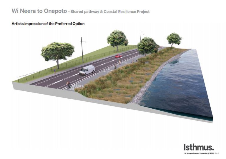
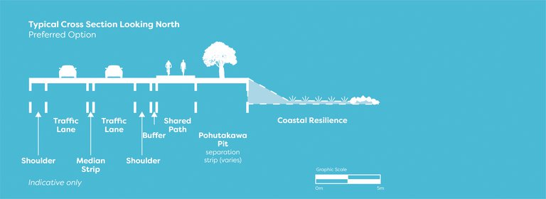
The main parts of the preliminary concept design include:
- Shared path – a 3m wide concrete shared path.
- Shoulder – a 1.2m wide shoulder to cater for on-road cyclists travelling at speed and provide space for broken down vehicles to pull over, clear of the traffic lane.
- Buffer – a 0.5m level surface between the edge of the shared pathway and the shoulder that caters for cyclists who stray off the shared path.
- Median strip– a 0.5m wide painted area to provide a separation between the north and south-bound lanes, as well as space for motorists to pass cyclists.
- Narrowed lanes – 3.2m wide traffic lanes (allowing the pathway to be located on the landward side of the Pohutakawa trees).
- Speed limit reduction to 50km/h along the full length – removing the 70km/h limits that currently apply in some sections. This will increase motorists’ travel times by approximately 20 seconds per trip.
- Crossing points – three crossing points (with raised cycle/pedestrian islands) to facilitate safe access to and from the pathway across Titahi Bay Road.
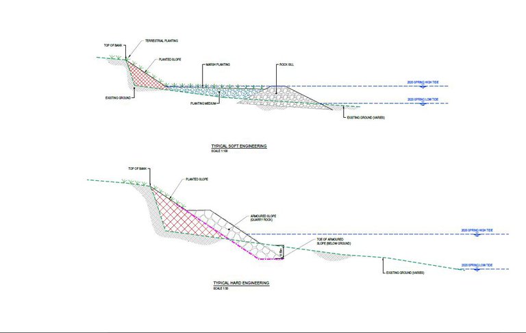
Coastal resilience:
- ‘Soft’ planted harbour edge – approximately 62% of the sloping coastal edge alongside Titahi Bay Road will be planted with coastal species naturally occurring around Onepoto.
- Saltmarsh – 8 – 9m wide sections of saltmarsh will be planted in a combination of oioi (which is mostly seen in the drier areas of mudflats) and sea rush (which lives where there is around four hours of seawater at high tide).
- Low rock “sill” or reefs – Located just off-shore (alongside the outer edge of the saltmarsh) low rock sills will make the shoreline more resilient by dissipating wave energy, and will also protect the neighbouring saltmarsh in the early years.
- Stormwater management and filtration – stormwater will sheet across the shared pathway and down the sloping coastal edge, into the saltmarsh which will filter and reduce sediment, heavy metals and other contaminants going into the harbour.
- ‘Hard’ (rock) harbour edge – the remaining 38% of the harbour edge will be rock armoured to protect the patches of seagrass within the inner harbour.
- Restored gravel beach – alongside Wi Neera Reserve.
The diagram below shows a typical cross section of the soft coastal resilience work which includes extensive areas of saltmarsh.
Community and stakeholder engagement has included:
- A stakeholder workshop in mid-2016 to identify project benefits and build a case for investment – resulting in development of an Investment Logic Map;
- Stakeholder and community consultation in late 2016-early 2017 on a proposal for a shared pathway and erosion protection (including ‘hard’ rock rip-rap) for the harbour edge alongside Titahi Bay Road;
- Consultation on the 2018-38 Long- term Plan seeking feedback on various pathway and coastal protection options with 73% of submitters expressing a preference to complete a pathway on the harbour-side and address the existing harbour-side erosion;
- Workshops with the community, stakeholders, local schools and Elected Members in early 2019 outlining, and seeking feedback on, a broad concept for the shared pathway and ‘soft’ coastal protection works along the harbour edge.
- Ngāti Toa engagement. Throughout the development of this project we have worked with Ngāti Toa, and a Ngāti Toa representative now sits on the project team.
- Stakeholder and community drop in sessions and feedback on preliminary design. These were held in the first half of 2021.
- Consultation on the 2021-2051 Long-term Plan. Consultation ran from February to April 2021 with submitters supporting the shared pathway and coastal resilience project.
Key aspects people have asked for:
Pathway:
- Harbour edge pathway (Submitters to the draft Long-Term Plan 2018-38 supported a harbour-side pathway and erosion repairs along the harbour edge)
- Provide crossing points (and access) onto the pathway along its length, e.g. at Te Pene Ave
- Provide a safety zone/separation between traffic and shared pathway users
- Consider cyclist and pedestrian safety in the design and potentially reduce traffic speeds
- Accessible for all ages and abilities
Harbour:
- The harbour has special value and is a priority (with the project)
- Enhance the mana of Te Awarua-o-Porirua
- Preference for a 'soft', resilient harbour edge solution - to protect the vulnerable coastal edge
- Minimise encroachment into the harbour, protect seagrass and kaimoana beds, improve harbour/harbour edge habitat
- Opportunity to improve stormwater management and filtration
- Ensure the work doesn't worsen flooding within Takapuwahia
Amenities:
- Improve connections to the harbour
- Retain the Pohutakawa trees if possible
- Consider beach creation at Wi Neera and opportunities to improve access for waka ama and other water-based events
- Consider parking and lighting-related needs, seating and pause/stopping points
Other:
- A desire for meaningful opportunities to have a say and provide feedback on the draft proposal.
| What you asked for |
Addressed in the preliminary concept design? |
How? |
|---|---|---|
| Pathway: | ||
| Harbour edge pathway | ✔ | The pathway is located along the harbour edge. |
|
Provide crossing points (and access) onto the pathway along its length, e.g. at Te Pene Ave |
✔ |
Three crossing points (including raised cycle/ pedestrian islands) are proposed – north and south of Te Pene Ave and across Onepoto Road. (These islands will facilitate safe crossing in two movements when traffic volumes are heavy.) |
|
Provide a safety zone/separation) between traffic and shared pathway users |
✔ |
A 1.2m wide shoulder and a 0.5m wide buffer are provided between the southbound lane and the shared pathway. Possible ‘treatment’ options for the buffer (e.g. whether to plant it out or create a grassy swale) are yet to be assessed. (Also see below) |
|
Consider cyclist and pedestrian safety in the design and potentially reduce traffic speeds |
✔ |
The 3m wide concrete shared path will enable recreational cyclists and pedestrians to travel safely in opposite directions without conflict. The speed limit will be reduced to 50km/h along the full length of Titahi Bay Road (and thus reduce the risk to pedestrians crossing Titahi Bay Road and users of the shared path.) Narrowing the traffic lanes to 3.2m will also help slow vehicle speeds and reduce the crossing width for pedestrians. |
| Accessible for all ages and abilities | ✔ |
The concrete pathway will be 3m wide and flat along the full length to enable recreational cyclists and pedestrians travelling in opposite directions to move safely and without conflict. |
| Harbour: | ||
|
The harbour has special value and is a priority (within the project) |
✔ |
Our community wants our harbour to be restored. The saltmarsh replanted as a result of this project will have a huge positive effect on restoring this large and important part of our harbour margin. The habitat created is a key part of our work to protect the harbour for generations to come. |
| Enhance the mana of Te Awarua-o-Porirua | ✔ | The coastal resilience works will begin to address the issues of harbour health. Ngāti Toa’s desire is to be able to obtain healthy kai moana and swim in the harbour. While a long term aspiration, this work will be a major step towards achieving it. |
|
Preference for a ‘soft’, resilient harbour edge solution – to protect the vulnerable coastal edge |
✔ |
‘Soft’ coastal resilience works will be provided along a significant proportion of the harbour edge (except some sections where a ‘hard’ (rock) edge is required to protect the seagrass). This combination of ‘soft’ and ‘hard’ coastal resilience will repair the existing erosion and dramatically improve the future resilience of the harbour edge. |
|
Minimise encroachment into the harbour, protect seagrass and kaimoana beds, improve harbour/ harbour edge habitat |
✔ |
The coastal works are to be only placed on what was part of the original reclamation in the early 1950’s. As the new rock sill and saltmarsh will not be located within the tidal mud flats this will help protect the slowly regenerating habitat that is left. |
|
Opportunity to improve stormwater management and filtration |
✔ |
Saltmarsh will play an important role in filtering contaminated stormwater and thereby reducing sediment, heavy metals and other contaminants going into the harbour. This will help improve water quality in the harbour. |
|
Ensure the work doesn’t worsen flooding within Takapuwahia |
✔ |
Water sensitive design features (which are part of the new coastal resilience works) will help slow flooding down and are intended to complement other stormwater management works in the surrounding catchments. |
| Amenities: | ||
| Improve connections to the harbour | ✔ |
People will be able to walk and cycle the length of the shared pathway and be able to watch the sea-life and coastal birds that will be using the new natural coastline just below the path. Where possible, pause points (incorporating seating, etc) will also part of the experience of connecting to our harbour. |
| Retain the Pohutakawa trees if possible | ✔ |
As the shared pathway will be located on the landward side of the Pohutakawa trees, most will be able to be retained (unless diseased and otherwise requiring removal). The Landscape Concept Plan (once developed) will highlight proposed landscaping for the harbour edge (including replacement of vegetation requiring removal during construction). |
|
Consider beach creation at Wi Neera and opportunities to improve access for waka ama and other water-based events |
✔ |
The restored beach along Wi Neera Drive will enable people to walk along the water edge and watch waka ama events and waka launching at the waka ramp. It will also be more attractive for other water-based events and waterfront activations on the adjoining Wi Neera Reserve. |
| Parking | ✖ |
There is no provision for parking along the length of the shared pathway. Users would be required to park at either end, along Wi Neera Drive or on the west side of Titahi Bay Road. |
| Other: | ||
|
A desire for meaningful opportunities to have a say and provide feedback on the draft proposal |
✔ |
Feedback from previous engagement has guided the preliminary concept design (as outlined above). You can give us your feedback now and we’ll keep you updated as things progress. |
And we’re still working on these items which are not addressed in the preliminary concept design - we'll update you and share details as we do this
| What you asked for |
When will this be addressed? |
Notes |
|
Provide a safety zone/separation) between traffic and shared pathway users |
In the detailed design stage |
While a 0.5m wide buffer is provided (alongside a 1.2m shoulder) in the preliminary concept design, we now need to assess possible ‘treatment’ options for this area. While two possible options could be to plant out the buffer (as requested by some) or create a grassy swale, we will need to consider ongoing maintenance requirements and associated costs. |
| Lighting | In the landscape concept design and detailed design stages |
Lighting will be provided. The next steps are to assess lighting-related needs (for pathway and road users) and develop a lighting plan. |
| Seating | In the landscape concept design and detailed design stages |
While not allowed for at this stage (in order to keep costs down) seating will be provided for through the landscape concept and detailed design processes so it can be added in future, as funds permit. |
|
Pause/stopping points |
In the landscape concept design and detailed design stages |
While not allowed for at this stage (in order to keep costs down) pause points will be provided for through the landscape concept and detailed design processes so it can be added in future, as funds permit. |
Project history
This project has a long history and affordability has been a key deciding factor along the way
The project began back in 2002 with a harbour-side boardwalk proposal jointly started by Porirua City Council and Ngāti Toa.
In 2007 the Takapuwahia Village Concept Plan included, among other things, a harbour-side timber boardwalk along Titahi Bay Road linking Onepoto to Wi Neera Drive.
There have also been a few feasibility studies exploring options to provide a path/cycleway and harbour edge erosion control works.
This is a complicated project. We need to look at erosion control, harbour ecology, climate change, road construction and maintenance and building a shared pathway. All of these matters need to be addressed through a resource consent process.
Taking community advice on board
During Council consultation on the project for the Long-Term Plan 2018-38, 73% of respondents who gave feedback on various pathway and coastal protection options supported a harbour-side path and erosion repairs to the harbour edge. The majority of feedback urged Council to complete the project sooner than proposed (at the time).
Key support decisions for the project
In 2019, Waka Kotahi NZ Transport Agency (NZTA) endorsed a 4-Stage Business Case for a shared pathway between the Porirua CBD and Titahi Bay. This project is stage two of that pathway.
In 2019 a coastal expert was engaged to develop a concept for the shared pathway, which saw the introduction of ‘soft’ coastal resilience/restoration works which people requested. Soft engineering is a significant departure from previous ‘hard’ (concrete & rock) engineering solutions.
This work, plus the earlier feasibility studies and option assessments and feedback from the community and stakeholders has informed how we have developed the current project and our assessment of the options.
The Onepoto Arm of Porirua Harbour has been extensively modified over the years. Almost all the present Onepoto harbour margin is reclaimed. The original coastline is 60-150 metres inland of the current coastline which was reclaimed during the 1950s. The rest of the Onepoto harbour arm has also been modified particularly with the development of SH1 and the railway lines, which have an ongoing impact on the health of the harbour.
The image below shows Titahi Bay road prior to reclamation
The image below shows the harbour margin pre and post the 1950s reclamation work
The extensive modifications carried out over the years have:
- Increased sediment and contaminant run-off into the harbour
- Eliminated naturally occurring coastal and freshwater wetlands
- Resulted in most small streams being culverted (piped)
- Eliminated all natural shorelines and nearshore ecosystems around most of the harbour.
Today’s natural habitat:
- There is ongoing decline of seagrass across the harbour. Just 2% of the original seagrass beds remain in the Onepoto area in 3 small patches along the Titahi Bay Road coastline (see seagrass maps below).
- Seagrass and salt marsh vegetation are important habitats in estuaries, providing a range of ecosystem services including sediment stabilisation, erosion mitigation, elevated biodiversity and nursery and/or feeding grounds for a range of invertebrates, fish and birds.
The images below show the current state of the seagrass beds
The current situation – Ongoing erosion of the harbour edge:
- The 1950s reclamation along the harbour edge is eroding slowly, particularly during major storms, and this is resulting in 1.5 – 2m high erosion escarpments (see images below)
- The Council has been looking for a way to address the erosion.
- Rates of erosion along the harbour edge differ due to different types of reclamation material and wave velocity.
- A recent harbour edge erosion assessment has shown that erosion repairs are required to approximately 44% of the harbour edge at some point within the next 1 – 10 years. The worst-affected areas are at the Onepoto end, south of Te Pene Ave and adjacent to Takapuwahia Reserve & Te Hiko St.
- We remain just one storm away from further significant damage to the harbour edge.
The images below show the current erosion issues along the Titahi Bay Road foreshore
Coastal erosion treatment options
There are three approaches we could take to protecting the harbour edge and addressing the erosion issues:
- ‘patch’ repairs as required to provide protection in high-risk areas (ongoing in response to need), or
- Long-term coastal resilience using soft treatments
- Long to medium term hard treatments.
Localised and ongoing erosion mitigation works will be required to repair and protect the road if we don't implement the preferred option.
Given the current erosion damage, rock armour protection would need to be installed along approximately 511m of the coast where the current bank edge is within 2m of the Titahi Bay Road edge.
Ongoing maintenance would be required along the length of the harbour edge, and it would be just one storm away from substantial, further damage that could potentially undermine the road.
Hard patch repairs could have a flow-on impact leading to erosion in neighbouring areas. This is known as ‘end effects’.
Installing rock rip rap would not provide any ecological benefits for the harbour and would not allow for the reinstatement of nearshore habitats.
Resource consent and coastal permits would be required from Greater Wellington Regional Council for reclamation and discharge and ongoing repairs over time.
Example of ‘patch’ erosion repairs
Hard engineering – such as rock riprap
Hard coastal engineering would protect the shoreline from the effects of erosion and sea level rise and would be long lasting.
Ongoing repairs could be required to the seawall following storm events.
Hard engineering would not provide any ecological benefits for the harbour and would not allow for the reinstatement of nearshore habitats.
The ease of consenting would depend on the footprint/reclamation required and a detailed assessment of the proposal. Hard engineering does present a more challenging consenting pathway (than for soft engineering). It is noted that both the proposed Porirua City District Plan and GWRC plans favour soft engineering (rather than hard) as a primary method to reduce damage from sea level rise and coastal erosion, protect coastal margins and preserve natural character.
Hard engineering works are harder to stage and in the longer term more costly.
The imagae below shows an example of harbour edge hard engineering alongside Portobello Road in Dunedin
The diagram below shows a typical cross section of a hard engineering approach
Soft engineering for coastal resilience – such as salt marshes
Soft engineering in coastal areas is used as a cost-effective way to protect shorelines from erosion and the effects of sea level rise associated with climate change. It also reduces the effects of flooding on marine environments and helps increase harbour health.
Small rock reefs (chenier) are placed just offshore and then saltmarsh is planted in between the shore and the reef. Natural examples can be seen around Pauatahanui Inlet where natural shell banks create the “rock reefs”. The rock reef and the saltmarsh dissipate wave energy. The larger the saltmarsh, the greater the wave energy dissipation. The rock reef is also called a sill.
The coastline along Titahi Bay Road is ideal for this type of coastal engineering (which has been used successfully around New Zealand and has worked since the early 1990’s). See more information about the benefits of soft engineering in the FAQ section below.
The advantages of this approach are that it creates a natural harbour margin that would protect the shoreline from the impacts of sea level rise and storm damage. It would also stabilise sediment entering the harbour and create habitat and be a food source for shellfish, fish, invertebrates and birds.
While more expensive to construct initially than patch repairs, it would cost about the same as hard engineering upfront. Longer term it would be cheaper to maintain, with repairs possibly only required after heavy storms. The ease of consenting would depend on the footprint/reclamation required. This approach could be staged.
The image below shows the shoreline of Pauatahanui Inlet, which is protected by soft coastal engineering - a wetland behind a chenier (a sandy beach ridge)
The image below shows a typical cross section of a soft engineering approach
FAQs
Early consultation
Options development
- Ecological assessments
- Transport and road safety assessments
- Engineering assessments
- Options development and analysis (Multi criteria assessment)
Information on options for Council
Preliminary concept design and cost estimates for Council decision
Next steps:
- Stakeholder and community engagement on the preliminary concept design through to 24 February 2021 – we are at this stage
- Landscape concept plan - 2021
- Consent-level design for the preferred option- 2021
- Technical assessments (including Cultural Impact Assessment) - 2021
- Resource consent applications - 2021
- Applications for external funding - 2021/22
How many options have been considered for this project?
Seven options have been assessed for this project, including:
- Option 1 – Narrow road lanes + harbourside path + coastal resilience + Wi Neera Beach
- Option 2 – Wide option (retaining the existing road lanes) + harbourside path + coastal resilience + Wi Neera Beach
- Option 3 – Value Engineered version of Option 1 + coastal resilience + Wi Neera Beach
- Option 4 – Project ‘Do Minimum’ – no path + only essential erosion repairs + Wi Neera Beach
- Option 5 – Value Engineered harbourside path + only essential erosion repairs + Wi Neera Beach (updated and re-costed from a 2009 feasibility report)
- Option 6 – Inland path + only essential erosion repairs + Wi Neera Beach (updated and re-costed from a 2009 feasibility report)
- Option 7 – Project ‘Do Nothing’ = Project Closes.
The options were assessed through a two-step Multi Criteria Assessment process (explained in more detail below).
What is a Multi Criteria Analysis (MCA) process?
MCA is a tool to assist and document decision-making where there are multiple options.
It helps carry out a comparative analysis of options (against consistently applied criteria) to decide which best meets a range of objectives set by stakeholders and the community for a project.
The MCA criteria were based on desired project outcomes, Waka Kotahi investment objectives, and community feedback from earlier engagement – and these were reviewed by Waka Kotahi and Ngāti Toa representatives. The assessment was carried out in two steps including:
- An initial ‘sieve’ – where all seven options were assessed against 8 broad criteria, and
- A detailed assessment of the two highest scoring options (Options 1 and 3) and the project ‘Do Minimum’ option (option 4) against 14 detailed criteria.
What were the results of the MCA?
Options 1 and 3 scored the highest against the initial ‘sieve’ criteria (step 1) and progressed to step 2 alongside the project ‘Do Minimum’ option (option 4 - which included only essential erosion repairs, rather than full coastal resilience). Option 1 (the preferred option) was the highest scoring option in the detailed assessment (step 2), followed by Option 3 and option 4.
Why did the Council agree to Option 1 (the preferred option) – is there a cheaper option that’d be almost as good?
The Council decided to proceed with Option 1 (the preferred option). Council believe this is the best solution to deliver on the project objectives and will also:
- Deliver on long-standing commitments to improve walking and cycling access from the CBD to Titahi Bay with a coordinated, quality, long-term solution
- Repair historical and current road edge erosion
- Restore the landscape quality of the harbour edge and greatly improve ecological values within the inner harbour
- Improve future resilience against erosion and the effects of sea level rise associated with climate change.
The option also has the support of our project partners – Ngāti Toa and Waka Kotahi (and meets Waka Kotahi co-funding requirements).
What is a preliminary concept design?
A preliminary concept design is a more detailed look at an option after all options have been looked at by stakeholders, experts and funders.
What’s included in the preliminary concept design?
At this point, the preliminary concept design (and initial cost estimate) includes the basic elements for the shared pathway and coastal resilience, such as:
- A 3m wide concrete pathway
- A 1.2m (narrowed) traffic lanes
- A reduction in traffic speeds to 50kmph along the length of Titahi Bay Road
- A 1.2m shoulder and a 0.5m buffer between the southbound lane and the shared pathway
- Three crossing points
- Coastal resilience works including:
- A ‘soft’ planted harbour edge alongside 62% of the Titahi Bay Road edge
- A ‘hard’ (rock) coastal edge in areas where there is seagrass in close proximity to the foreshore
- Saltmarsh wetland
- Low rock sills (or reefs)
- A restored (gravel) beach along Wi Neera Drive
- Improved stormwater management and filtration
- Improved lighting
‘Nice to have’ elements like seating and pause points (areas with signage or a seat for users to take a break) aren’t included at this point as we’ve tried to keep the costs down and don’t yet know how much external funding we’ll be able to source. These elements will be provided for as we develop the landscape concept and work through the detailed design processes in order that they can be added in future, as funds permit.
There is no provision for parking along the length of the shared pathway. Users would be required to park at either end, alongside Wi Neera Reserve, or on the west side of Titahi Bay Road.
Has the preliminary concept design been agreed – is it final?
While some aspects of the concept (such as the harbour-side route, pathway width and ‘soft’ coastal resilience) are unlikely to change, there’s more work to be done on other aspects such as the buffer zone (and treatments within that area), the location of crossing points, and lighting (through the developed design stage). Seating, cultural elements and pause points will be provided for as we develop the landscape concept plan and work through the detailed design process so they can be added later as funds permit.
We’ll progressively refine the details as we move through the resource consent and design processes and will be able to share more details and invite feedback on those elements in due course.
What is a shared pathway?
A shared pathway is a widened footpath (separated from the road) that may be used by pedestrians, cyclists, riders of mobility devices and riders of other non-motorised devices, at the same time.
What is a Value Engineering (VE) process?
Value engineering is a systematic, organised approach to providing necessary functions in a project at the lowest cost. It promotes the substitution of materials and methods with less expensive alternatives, without sacrificing functionality. That is – it’s a way of finding cheaper ways to achieve the same project outcome.
Why not just repair the harbour edge erosion – surely that’d be a lot cheaper?
Current erosion damage is such that rock armour protection would need to be installed along approximately 511m of the project site where the current bank edge is within 2m of the Titahi Bay Road edge.
While ‘patch’ repairs would be cheaper initially, ongoing maintenance would be required along the length of the harbour edge, and it would remain just one storm away from substantial, further damage that could potentially undermine the road. ‘Hard’ patch repairs could also have a flow-on impact leading to erosion in neighbouring areas – known as ‘end effects’.
Four of the seven options we considered included essential erosion repairs (i.e. patching) to the harbour edge, instead of coastal resilience. As these options did not score well against the MCA criteria (or the other options) they didn’t proceed beyond the stage one initial ‘sieve’.
It’s also noted that this approach would not provide any ecological benefits for the harbour or allow for the reinstatement of nearshore habitats.
Why has this project been so difficult to deliver over so many years?
The recurring stumbling block has been the mis match between cost and available budgets.
What is the current budget?
The 2021-51 Long-term Plan includes a capital budget of $10.7m for the project. This is broken down as: $3.6m (PCC), $3.9m (Waka Kotahi - NZ Transport Agency) and $3.2m (external funding sources).
What is the estimated cost?
The preferred option has an estimated capital construction cost of $10.7m (including 30% contingency).
Estimated construction costs for the key elements are: $4m for the pathway, $6.1m for coastal resilience alongside Titahi Bay Road, and $0.6m for Wi Neera Beach improvements.
The final cost won’t be known until we have obtained resource consent, completed detailed designs and expert costing reviews, and we have a preferred tenderer.
With such a big ‘gap’ between the project budget and the cost, how will the Council be able to build the pathway?
Council’s contribution of $3.6m to the project, has been confirmed as part of the 2021-51 Long-term Plan. Further funding is being sought from Waka Kotahi NZ Transport Agency ($3.9m) and external funding sources ($3.2m). Applications will start in the new year.
We have a commitment in principal from Waka Kotahi. Further funding sources will be investigated over the next 12 to 18 months.
Could the estimated cost change?
Yes. While the $10.7m does include 30% contingency, the cost estimates are preliminary and based on preliminary concept drawings. These costings will require an expert costing review, and at a later stage we may seek contractor input to explore potential construction-related efficiencies. The true final cost won’t be known until the tender for construction closes.
What if Council can’t secure the external funding needed?
We have a Funding Plan which includes how we aim to request additional funding from other funding organisations.
If Waka Kotahi and external funding can’t be secured to meet the budget shortfall, the project will be closed, and the capital funding returned to the Transport renewal programme, and to City Partnerships to complete Wi Neera Beach (subject to resource consent). Coastal erosion issues along Titahi Bay Road would be managed through the ‘business as usual’ Transport maintenance programme.
What is Waka Kotahi’s role on the project?
Waka Kotahi (NZ Transport Agency) is one of our project partners and has been closely involved in, and helped shape, the project to date.
This project is stage 2 of the 4-stage shared pathway project (between the Porirua CBD and Titahi Bay) endorsed by Waka Kotahi in 2019. We are working closely with our Waka Kotahi Investment Advisor through the concept design process to further maximise the funding opportunities available towards the developed design and capital works stages of the project.
To date, Waka Kotahi has been very supportive of the harbour-side pathway proposal, along with the coastal resilience works to restore the harbour edge and protect the road.
Does the preferred option incorporate previous feedback?
Yes, feedback received over the years from Ngāti Toa, the community and other stakeholders has helped shape the preliminary concept design for the preferred option.
Will the pathway be safe for all users?
Yes, we have undertaken a safety audit of the preliminary concept design for the preferred option to ensure it is safe for all users. The traffic speed on Titahi Bay Road would also be dropped to 50kmph along the full length to improve safety and reduce the risk to people crossing the road and users of the shared path.
Why is the shared pathway going on the eastern (seaward) side of Titahi Bay Road?
Feedback received on this project during community consultation on the 2018-38 Long Term Plan showed a clear and strong community desire for a cycle and pedestrian pathway linking Titahi Bay – with 73% of submitters on the project in Long-Term Plan expressing a preference for a harbour-side pathway.
Did you look at putting the shared pathway on the landward (west) side of Titahi Bay Road?
Yes. One of the seven options assessed through the MCA process included a pathway on the landward side of Titahi Bay Road, with essential erosion repairs along the harbour edge. This option didn’t score as highly as other options through the MCA process and wasn’t progressed beyond the first (initial ‘sieve’) stage.
Will the shared pathway project impact on the Pohutakawa trees along Titahi Bay Road?
An audit of the trees along this stretch of Titahi Bay Road has revealed that some are diseased and will need to be removed – however our aim is to keep as many trees as possible.
What is soft engineering for coastal resilience?
Soft engineering in coastal areas is used as a cost-effective way of protecting shorelines from erosion and the effects of sea level rise associated with climate change. It also reduces the effects of flooding on our marine environments and helps increase harbour health.
To make a shoreline resilient, we create small rock reefs or “sills” which are placed just offshore and then plant saltmarsh between the shore and the reef. The rock reef and the saltmarsh dissipate wave energy and protect the shoreline. The larger the area of saltmarsh, the greater the wave energy dissipation. Natural examples can be seen around Pauatahanui Inlet where shell banks create the “rock reefs”.
The low tidal mudflats along Titahi Bay Road are ideal for this type of coastal engineering (which has been used successfully around New Zealand and has worked since the early 1990’s).
What are the benefits of soft engineering on harbour ecology and water quality?
The present day Titahi Bay Road shoreline was formed by reclamation in the 1950’s and in many areas lies 60-150m seaward of the original natural shore. Just 2% of the original saltmarsh area (which was once extensive) is left in the Onepoto arm of the harbour, two thirds of which is now rock armoured.
If a soft engineering approach is taken, harbour water quality would be improved through stormwater filtration by the saltmarsh created along the harbour edge. These saltmarshes would reduce sediment, heavy metals and other contaminants going into the harbour and provide a significant habitat for our bird species which are currently declining. Salt marsh is a large food source for our coastal ecosystems in Porirua.
How will this project improve harbour ecology and water quality?
Capturing sediment
The present day Titahi Bay Road shoreline was formed by reclamation in the 1950’s and in many areas lies 60-150m seaward of the original natural shore. Two thirds of the coast around our harbour is rock armoured. Just 2% of the saltmarsh is left in the Onepoto arm of the harbour.
By replacing rock with salt marsh we can capture sediment and stop it from damaging other parts of habitat in the harbour.
Salt marsh is also a large food source for our coastal neighbours in Porirua. Each year, over 400 tonnes of food is provided through the salt marsh to our coastal species in Pauatahanui Inlet. The saltmarsh in Onepoto will also provide a significant habitat for our bird species which are currently declining.
This length of saltmarsh means a massive improvement for harbour health.
Water sensitive design
For this project we are using water sensitive designs to manage water. What this means is using swales and saltmarsh (coastal wetlands) to slow down and treat stormwater before it gets into the harbour. Swales and wetlands are natural wastewater treatment plants.
Saltmarsh as a wetland treatment for contaminants
Contaminants like heavy metals and organic compounds from our cars and trucks are deposited on our roads and then washed into stormwater when it rains. The contaminants have a significant, detrimental impact on harbour health.
Saltmarsh is a coastal wetland. As a wetland, it can filter out contaminants in our stormwater. The marsh absorbs heavy metals and stores them, which means they are no longer deposited on the tidal mudflats where lots of our harbour life lives. The saltmarsh also slows down the effects of heavy rain and flooding caused by stormwater.
Grassy swales
Along the shoreline next to the pathway we may also put in swales which are u-shaped areas to hold and filter water. The swales can be either grass or wetland plants to filter out contaminants and slow down flooding.
How will harbour landscapes be improved?
The slopes next to the shared pathway will be planted with coastal species naturally occurring around Onepoto. The salt marsh formed will turn into a landscape similar to that along Grays road at Kakaho Estuary (see below). Pause points or viewing areas will allow people to see the saltmarsh close up and in time, the many types of coastal bird species that people enjoy around Pauatahanui Inlet. Two types of marsh plants can be used – oioi (which is a lovely golden brown colour and is mostly seen in drier areas of mudflats) and sea rush (which is a blue grey colour and lives where there is around four hours of seawater at high tide).
Pauatahanui estuary